What is a UAS?
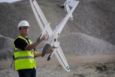
In the past an aircraft was just called an ‘aircraft’, without the qualifiers ‘manned’ or ‘unmanned’ since the ‘manned’ version was the only option. Of course, the unmanned ones have been around nearly as long as the aircraft designed for travel or transportation, but they were previously flown by the military – the warlords called them ‘drones’ – or model airplane enthusiasts. With the emergence ofunmanned aerial systems(UASs) came the need to distinguish ‘manned’ from ‘unmanned’, so today we haveUASsversusMASs(可替换主体系统)。
(By Mathias Lemmens, senior editor, GIM International)
Are UASs here to stay or are they just a fad, destined to join countless other products of human ingenuity buried in the graveyard of ‘nice but useless’ inventions? The signs clearly point in the direction of ‘here to stay’, so vigorously in fact that some people fear the UAS will soon replace its manned sister. Do UASs really pose a threat to regular airborne surveys? I don’t think so. That fear is primarily sparked by humankind’s imperfect perception of evolutionary changes and tendency to perceive life as a battle. Humans are inclined to think in terms of competition and conflicts. Humans are also inclined to look at the future from the perspective of the status quo and are generally poor at noticing gradual changes. But change is permanent. Although the future is difficult to predict, there are some anchor points. Firstly, the world population continues to grow while planet Earth refuses to expand its space. Accurate, detailed and up-to-date geoinformation is vital if we are to feed, clothe, house and transport the billions of inhabitants. Secondly, in developing countries the unstoppable move from rural villages to the cities is accelerating in pace. Thirdly, sea level rise is a global inescapability which poses severe risks of flooding. Implementing countermeasures requires lots of geoinformation. In short, the need for geoinformation is increasing all the time, and that information can be provided by satellites, MASs and UASs. However, the features of the platforms differ and so too does the data acquired by the sensors on board.
High accuracy
在某种程度上,准确性和空间资源lution of UAS-collected data is comparable to geodata from MASs. MASs are well suited to capturing large areas with metric cameras which may weigh up to 100 kilograms for high-accuracy mapping. In contrast, the use of UASs is appropriate when small areas have to be captured with high accuracy, high detail and in three dimensions using lightweight sensors. In terms of threats to the MAS, the permanent Earth observation (EO) satellite should be mentioned first as the spatial resolution of that imagery reaches an astonishing 35 centimetres, enough for topographic mapping up to scale 1:10,000. Added to this, some EO satellites have pointing agility allowing them to capture the same site as often as once a day and to minimise the number of scenes hidden by clouds. Hence, the type of platform largely determines the temporal and spatial resolution of the geodata captured.
New technologies either flourish or vanish. They flourish when the user base expands. UAS technology has the warm interest of a broad group of professionals in the geodisciplines since it has proven reliable in capturing 3D geodata of small areas and monumental buildings. In the meantime there is some confusion about what a UAS actually is and does. “Let’s purchase a drone!” exclaim colleagues who are not trained in geomatics. “You can buy them for a few hundred euros at the shop around the corner and it may boost our influx of students.” Geomatics professionals do not talk about drones but rather UASs, and the UAS is more than the platform alone; it also includes the sensors to capture geodata and the dedicated, advanced software to process the raw data into useful information in a highly automated manner. When buying a UAS, you’re paying for the sensors and the software rather than the platform.
This Endpoint column was published in the May 2015 issue of188金宝搏特邀.
Make your inbox more interesting.Add some geo.
Keep abreast of news, developments and technological advancement in the geomatics industry.
Sign up for free


