Three Articles about Digital Twins that Really Add Value
Is the concept of the digital twin merely a hype, or do digital twins actually offer lots of opportunities? As these three articles show, they really can add value – especially if you remain critical and take a nuanced view of their applications. And on another positive note, all the mainstream attention being paid to digital twins right now highlights the value of geoinformation – which is good for the geospatial industry too!
Digital Twins: A Comprehensive Solution or Hopeful Vision?
数字双已经获得的概念ignificant momentum in the geospatial domain since 2016. Although there is some consensus on the basic features of a digital twin, some critical reflection is still necessary to make the concept tangible. Only then can the digital twin be implemented as a technical solution that scales to real-world problems rather than being an abstract vision for partial solutions. Let’s take this opportunity to reflect on the practical digital twin-related challenges in the geospatial domain.
‘Digital twin’ is a catch-all term that has come to be used in many different ways in the geospatial domain since its introduction a few years ago. Without a common understanding of what the concept entails (and what is new to it), DTs can end up being treated as unproductive goals on their own, rather than the best means to support current challenges such as climate adaptation and urbanization. There is also a risk of non-directed, fragmented solutions with unrealistic promises, which can fail to implement DTs as a real-world solution beyond pilots and projects.Read the entire article here
Building a Digital Twin for Germany
The German Federal Agency for Cartography and Geodesy (BKG) is creating a digital twin of Germany that can be used to simulate various future scenarios in order to adequately address societal challenges, such as the increasing use of land, rising energy demands and extreme weather. This digital replica of Germany will be built as an intelligent 3D world containing all the essential geospatial objects, enabling the relevant processes to be mapped holistically and in relation to each other based on a common data foundation. This is intended to support faster, more informed and more reliable decision-making.
Digital Twin Germany goes far beyond the structure of a 3D model. In addition, the aim is to develop and establish communication channels and networks of stakeholders at federal and state level. In general, it should enable policymakers and decision-makers to monitor specific conditions and test scenarios. Predictions can be made about how a system will react to changes and modifications. This creates new decision-making tools with which public-sector employees can optimally manage their tasks. For example, one interesting application in the federal administration is a nationwide environmental monitoring system.

3D City Models and Their Multitude of Purposes
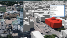
3D city models can be used in map applications, urban planning, virtual events and as a starting point for various other applications. At Aalto University, research into the topic has focused on ways to use city models in the capital region of Finland and on applying new 3D mapping technologies to the modelling of cities.
The Helsinki Smart Digital Twin 2025 project focuses especially on the utilization and development of the capital's 3D city models. Its aim is to discover new and more efficient ways of using city models in different processes and business life. The project seeks to increase knowledge and grow the expertise and economic basis between the City of Helsinki, its citizens and companies.
Make your inbox more interesting.Add some geo.
Keep abreast of news, developments and technological advancement in the geomatics industry.
Sign up for free

