SuperSurv对香港的未来城市规划
The Planning Department in Hong Kong has purchased SuperGeo’s mobile GIS app, SuperSurv for Android, and is now evaluating the possibility of using it for doing field survey works. The Planning Department intends to provide accurate urban land use data in order to plan long-term policies. To achieve it, a comprehensive GIS which integrates vector and raster data and allows users to collect spatial data will become extremely important.
Due to a lack of construction and repair works over the years, old houses in Hong Kong have became dangerous and detract from the city’s appearance. Therefore, the planning department has been actively promoting the city's renewal and rebuild project.
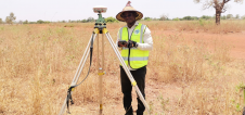
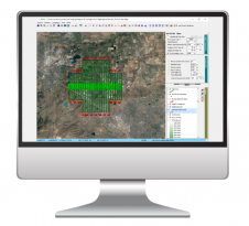
With the GIS data collection app, SuperSurv for Android, field workers can either capture data with built-in GPS of smart devices or use external GNSS devices to elevate accuracy. The app can also connect with server GIS to timely update on-site situation for officers to make decisions.
The offline function of SuperSurv is useful in assisting field workers to collect data, document the progress of work in internet-free environments, and maintain the city's appearance effectively and efficiently.
Make your inbox more interesting.Add some geo.
Keep abreast of news, developments and technological advancement in the geomatics industry.
Sign up for free