NavVis IndoorViewer Update Creates 360 Degree Walkthroughs
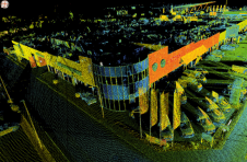
Indoor spatial tech provider NavVis has announced a new feature in the latest update to their IndoorViewer app - the ability to create immersive 360° walkthroughs from structured E57 point cloud files.
Web-based IndoorViewer creates digital twins from point clouds, panoramic images and maps - extending the use of point clouds beyond building plans and BIM models and allowing remote, virtual access to complex sites and projects.
“IndoorViewer最初开发display the data captured by our indoor mobile mapping system in a way that is accessible to every user. In recent years, we have seen that making scan data available to every building stakeholder is fulfilling an unmet need,” said Felix Reinshagen, NavVis CEO. “Many of our partners using system for conventional scanning projects are offering IndoorViewer as an additional deliverable.”
This feature bridges the gap between panoramic images and static point clouds by automatically rendering 360° images from E57 files, meaning that immersive presentations can be created and shared online without the need to download or purchase additional software.
The E57 panorama extractor is available as part of a free software upgrade to IndoorViewer subscribers.
Make your inbox more interesting.Add some geo.
Keep abreast of news, developments and technological advancement in the geomatics industry.
Sign up for free