Murphy Surveys Expands Subsurface Mapping Team
This article was originally published inGeomatics World.
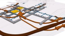
Murphy Surveys has introduced the IDS GeoRadar Stream C as their latest addition. The Stream C solution will augment their existing service offering and will provide clients with faster, more accurate, real-time 3D mapping of underground utilities and buried features. Furthermore, they have announced two vacancies for Utility Surveyors in the UK.
“We’re experiencing a rise in demand of subsurface mapping in the UK,” said Kai Duebbert, Managing Director Murphy Surveys. “Our clients want increasing visibility of the location and position of underground utilities, to make more informed decisions on the design and build of a site. But, more importantly the knowledge that can prevent risk of life and unnecessary project delays and costs should a utility be compromised during construction works.”
“The space under our cities is getting busier, so it’s as important as ever to safeguard the works taking place all over London and across the UK. The recent purchase of the Stream C will allow us to very quickly produce a 3D reconstruction of the underground utility network and automatically detect buried pipes and cables in real-time, helping us to deliver projects much faster and more accurately than ever before.” added Duebbert.
Murphy Surveys are also actively recruiting for specialist Utility Surveyors who have the skill, knowledge and experience in underground mapping.
If you’re interested in the position, send your CV along with a covering letter torecruitmentuk@murphysurveys.co.ukor visitwww.murphysurveys.co.uk/careers/
For more information on the subsurface mapping services visitwww.murphysurveys.co.uk/survey-services/
Make your inbox more interesting.Add some geo.
Keep abreast of news, developments and technological advancement in the geomatics industry.
免费注册

