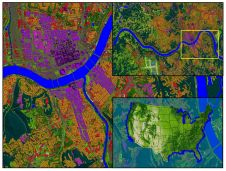
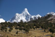
Land Info Completes 10m Countrywide Mapping Dataset of USA
Land Info Worldwide Mapping recently completed up-to-date 10m-resolution thematic raster GIS data covering all 50 US states. Optimized for low-band (broad-area coverage) 5G wireless planning, the dataset supports additional applications including utilities, insurance and government, and complements Land Info’s 1m-resolution datasets that are used for mid-band and high-band 5G in more densely populated areas. Land Info Worldwide Mapping is a leading provider of mapping solutions for 5G wireless in North America.
"The dataset is unique in that, in addition to using 2020-2021 Sentinel imagery and numerous ancillary layers, we were able to create best-in-class mapping by incorporating aerial-derived Digital Surface Model (DSM) elevation data into our processing via our long-standing partnership with Hexagon’s HxGN Content Program," says Land Info President Nick Hubing.
Imagery, DSM and Ancillary Layers
TheHxGN Content Programmeoffers high-resolution, countrywide aerial imagery and elevation data of the contiguous United States and Western European countries. Hexagon continuously advances the programme with higher-resolution products for digital twin initiatives.
“We are proud to support Land Info’s land-use/cover mapping solution with our high-quality DSMs,” says John Welter, president of Geospatial Content Solutions at Hexagon. “Land Infois a well-established partner of Hexagon, and the partnership enables various industries to gain real-world analytics for reliable insights and better-informed decision-making.”
Land Info’s proprietary automated geospatial processing technologies include object-based image analysis and artificial intelligence where smart rulesets analysed, classified and merged the imagery, DSM and ancillary layers into a single information-rich dataset. There are currently just over 20 classes, and additional classes can be added upon request.

Make your inbox more interesting.Add some geo.
Keep abreast of news, developments and technological advancement in the geomatics industry.
Sign up for free