ERP软件与Tatukgis SDK开发
TownSuite Municipal Software is an Enterprise Resource Planning solution developed specifically for municipal governments. It aims to eliminate reliance on third party solutions by providing a configurable and comprehensive collection of software tools connecting municipal departments and community stakeholders. The TatukGIS Developer Kernel (.NET and ASP.NET Enterprise editions) is used to develop and improve TownSuite Mapping, an intuitive GIS/mapping application that is integrated into the other TownSuite applications.
GIS.for the Organisation
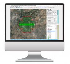
由于开发人员内核自行许可,因此可以免费获得版税或运行时费用,因此Townsuite映射可以经济地集成到开发的每个模块中,以便在整个组织中利用可用的GIS数据。这意味着任何授权的工作人员(不仅仅是GIS专家)可以连接和高效地使用市政映射信息。
Municipalities can choose from Financial, Planning, GIS-Mapping, and Asset Management applications and a variety of Web Service applications providing access for stakeholders via Customer, Recreation, Complaints, Employee, and Maintenance portals. AllTownSuite Municipal Softwareapplications are designed to work together. Software improvements are provided on an ongoing basis, making TownSuite a living software that grows, adapts, and evolves to fulfil the needs of over 160 municipal organizations across Canada, as well as in Sri Lanka and Bermuda.
For larger municipalities with advanced GIS requirements, Developer Kernel support for enterprise spatial databases (Oracle Spatial, MSSQL Spatial Server, PostGIS, Geomedia, ArcSDE...) enables scaling TownSuite to connect to, edit, and query data in multiple enterprise-level spatial database formats. This eliminates expenditure of resources on evaluating and/or migrating to alternative GIS platforms, and instead retains existing GIS tools. Other features include full integration with Google Maps and Google Earth, 3D mapping presentation with floodplain simulations, DTM draping, and light and shadow simulation.
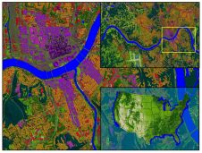
图片:公民地址,所有者信息,分区和水和下水道基础设施以及从映射中检索的挫折。
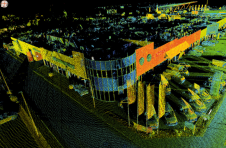
DK 3D engine utilised to drape aerial photos over a digital elevation model to present terrain relief and simulate flooding.
让你的收件箱更有趣。Add some geo.
Keep abreast of news, developments and technological advancement in the geomatics industry.
免费注册