Carbomap与Riegl的长期UAV飞行执行激光扫描
本文最初发表在地理学世界。
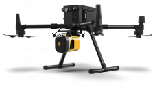
与High Riegl,Uave和Edinburgh大学合作Carbomap宣布了一个固定翼,长距离无人机的Riegl Vux-1LR调查级波形激光扫描仪的第一个成功演示飞行。
这可能是第一次如此高性能扫描仪在固定的翼UAV上飞行,具有长期(8小时)和长距离(1,000公里)的先进规范。凭借厘米级三维精度,该开发将大大提高全球对高质量激光扫描(称为LIDAR)的可访问性。
Obtaining high quality 3D data can be very expensive using conventional airborne surveys. It is difficult to process without specialised software, and as a consequence, it is rarely available in most developing nations. By bringing such instruments together into a single UAV system (Forest-Lux (F-Lux)), together with its own solution-focused software, it is now possible to get a system that can be a local asset, under local stakeholder control, and be operated at an affordable price in any country in the world.
F-LUX的技术细节:
- F-LUX在近实时处理数据以产生高质量的指标。
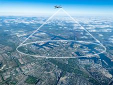
- 有1,000公里的范围,可以在一天内覆盖高达800平方公里。
- Uses the RIEGL VUX-1LR LiDAR sensor
- 可以在高度最高650米,收集全波形LIDAR数据
- Uses instant-Omega software so users have the data already in the Cloud when they return to base
F-LUX的目标是成为当地或国家资产;这意味着动员系统的成本必须低,这显着降低了收集数据的总成本。F-LUX可以应用于一系列其他应用,例如映射电力线,道路和其他基础设施以及农业。快速部署驱动器的能力意味着它也可以用于灾后情况,收集和处理高质量和重要数据的需求。


