3D City Models and Their Multitude of Purposes
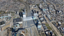
3D city models can be used in map applications, urban planning, virtual events and as a starting point for various other applications. At Aalto University, research into the topic has focused on ways to use city models in the capital region of Finland and on applying new 3D mapping technologies to the modelling of cities.
Vast, three-dimensional (3D) models of urban environments are already a familiar sight – you might explore one in a video game, for example – but they can also be used for cities' information services, research and commercial purposes. 3D city modelling has become a common task in producing geographic data for cities. The Research Institute of Measuring and Modelling for the Built Environment (MeMo) at Aalto University in Finland both studies city models and produces the data used in their creation.
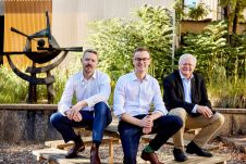
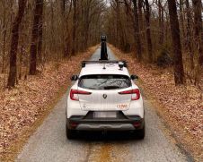
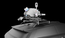
The MeMo research group produces data for city models through a variety of 3D measurement and modelling methods. In particular, it uses methods based on photogrammetry or laser scanning, including drone-based aerial imaging, terrestrial laser scanning or SLAM-based mobile mapping, says Arttu Julin, a doctoral student with the group.
Three-dimensional city modelling and open data have both made significant advances in Finland, to the point where researchers can use complete sets of data, saving them the effort of beginning at the mapping stage.
"Current research focuses instead on increasing the level of detail of 3D city models in areas of interest, for example to support urban development. To achieve greater detail in a smaller area, we can use laser scanning or drone-based measurements. These methods are also a regular part of our research work," adds Postdoctoral Researcher Juho-Pekka Virtanen.

Building Smart Data Models
MeMo researchers are currently participating in two projects related to the use of 3D city models in the capital region: Helsingin älykäs tietomalli 2025 (Helsinki Smart Digital Twin 2025) in collaboration with the City of Helsinki, and theKAOS(Developing the knowledge capital in 3D city modelling) project funded by the European Social Fund.
"The Helsinki Smart Digital Twin 2025 project focuses especially on the utilization and development of the capital's 3D city models. Its aim is to discover new and more efficient ways of using city models in different processes and business life. The project seeks to increase knowledge and grow the expertise and economic basis between the City of Helsinki, its citizens and companies," according to Julin and Virtanen.
In the project, mapping campaigns are undertaken for research purposes. Research questions deal with increasing the model's level of detail in a given area and integrating building interiors to the 3D city model. As these kinds of datasets are not directly and freely available, they must be produced within the project, for example through SLAM laser scanning. The project is being conducted in close collaboration with the 3D team of the City of Helsinki.
The KAOS project is aimed at increasing expertise related to city models in the cities of Espoo and Helsinki and in companies. Instead of research, the project is weighted toward communications, events and mutual development between stakeholders. Virtanen says that areas that still needs strengthening are the technical basis for city modelling, 3D city models' use as a whole that supports the processes of an entire organization and the utilization of 3D city models as shareable data resources.
三维城市模型在世界各地
The Finnish capital region is by no means the only area from which city model data has been gathered. In both Helsinki and Espoo, the city information modelling is based on CityGML, the established format for producing city information models. The creation of similar information models has been prolific especially in Europe, with models created of cities like Rotterdam, Berlin and Vienna; Switzerland even hasa national-level projectaimed at modelling the entire country.
"In addition to semantic CityGML information models, there are many visually impressive, photorealistic 3D city models, such as the City of Helsinki's separate 3D mesh model of the city. Realistic city models – focused on details and visually appealing appearances – and their production have also been among our key research areas here at Aalto. It's apparent that the 'photorealistic' and 'semantic' approaches are drawing closer to each other. An example of this would be the strong trend of developing and building digital twins of cities based on gaming technology," notes Arttu Julin.
"3D city modelling in the capital region is on an international level. This means that many of the questions we study in our research projects are interesting and timely overseas as well. Many European cities are currently grappling with similar questions," comments Virtanen.

Making sense of urban environments with the help of applications
The research group developed the朋友velututka application(Service Radar, only available in Finnish) as a freely available example, based on service data from City of Helsinki APIs and 3D models of the city itself. "The main idea behind Palvelututka is to combine open data sets that are already available into a single, browser-based application. Here, the 3D model serves as a platform for presenting information from different sources, offering a three-dimensional environment for interpreting that information," Julin says of the application.
The application can be especially useful when piecing together a multi-layered urban environment, such as Kalasatama in Helsinki. According to Virtanen, the 3D model offers a significantly simpler and more visual way of presenting information related to an environment, as navigating these kinds of places is often difficult with two-dimensional maps alone. The朋友velututka source codehas also been made available free of charge.

City model data for research, commerce and more
City model data can also be used in various ways to support research. Julin says that city modelling offers countless approaches to the study of geoinformatics, geography and architecture, among others, as it provides many ways to visualise urban environments and a basis for different analyses and simulations.
"In addition to presenting information, a city model can also be used for the purposes of analysis. A city information model that combines other types of information with the physical appearances of locations can be especially useful for computational analysis. In our publication "Near Real-Time Semantic View Analysis of 3D City Models in Web Browser" we present an analysis in which geographic data was added to a city information model in order to assess views in a city – how much vegetation or water can be seen from a window of a building, for example. This kind of analysis based on a city model could be used when studying real estate economics or urban experiences, for example. Of course, conducting such studies would also be geoinformatics research in and of itself," Virtanen says.
City models have found commercial users especially among companies that deal with urban environments. City models can be appealing to many other fields as well, as they offer the possibility of presenting information alongside navigation and provide a starting point for various simulations, which means they can help in planning deliveries or events. News agencies, other media companies as well as the entertainment and game development sectors have also made use of city models. During the past year, models have also become a part of various virtual events.
Citizens can benefit from services built on city models, as well. "For example, theHelsinki Energy and Climate Atlasgives anyone the opportunity to check out the solar power production potential of their home," Virtanen says.
The original version of this article appeared on the website of Aalto University, Finland.
Make your inbox more interesting.Add some geo.
Keep abreast of news, developments and technological advancement in the geomatics industry.
Sign up for free

