UAS Lidar for Ecological Restoration of Wetlands
新技术如何帮助保护环境
湿地是必不可少的生态系统,为整个社会带来了许多好处。但是它们的功能在很大程度上取决于流域的水文学和地形,从而产生了监测的需求。但是,在湿地中,使用陆地地形调查方法可能是一项具有挑战性的任务。洪水泛滥的地区,泥泞的地形和低植被可以大大减慢甚至可以防止测量师的运动,而高大的植被可能会阻碍GPS接收。正如本文概述的那样,诸如机载或UAS激光雷达之类的先进技术为测量湿地的水文学和地形提供了有趣的替代方法。
Wetlands are ecosystems where water meets land, such as river marshes, peatlands or flooded forests. They are often undervalued and have become globally threatened; since 1900, two thirds of natural wetlands have been destroyed. Besides conserving the remaining wetlands, there is a need to help wetlands recover from degradation or fragmentation which can cause the loss of their essential ecological functions and consequently the loss of all the benefits they provide to society as a whole. In many cases, wetland problems have originated from the alteration of the channel path or other physical characteristics, which in turn has led to habitat degradation and loss of biodiversity. Therefore, the understanding of the physical terrain structure and natural hydrology is essential for successful wetlands restoration.

Case study: Mou de Pleure bog
The Mou de Pleure bog, located in the Franche Comté region of France, is a prime example of wetlands degradation. Since the end of the 19thcentury, the bog has suffered wide-ranging damage. One of the most important interventions was the digging of a ditch in the 1980s to improve drainage of cultivated land. This hydrological alteration led to various negative impacts such as a decrease in water storage capacity (which normally supports flood prevention), forestation and loss of previously observed rare local species. The Mou de Pleure is one of the region’s few peatlands that is located on the plains and, according to ancient studies, it used to be the widest and the most flourishing of all the swamps on the Bresse plain. The Regional Conservatory for Natural Areas (CEN) therefore initiated a restoration project.
The use of UAS Lidar
To study the hydromorphology of the area for the restoration project, an accurate digital terrain model (DTM) was required of the bog and its watershed. A French aerial mapping operator called L’Avion Jaune, based in Montpellier, decided to use a Lidar scanner on a multirotor platform to conduct the survey.
The study area covered around 50 hectares with, in the centre of the bog, a dense wooded areaalong the Mou streammeasuring 900m long by 200m wide. Beyond the forested area, the rest of the Mou de Pleure bog comprises meadows and cultures. The use of an unmanned aerial system (UAS), especially a multirotor unmanned aerial vehicle (UAS or ‘drone’), is typically well-suited for an area of this size, which is too extensive to be surveyed cost-effectively using terrestrial techniques but too small to perform an aerial survey using a manned aircraft. Besides that, the muddy environment and the dense vegetation make it difficult for terrestrial surveyors to access the terrain.

Another challenge in this survey is the high vegetation cover, as the degradation of the bog has led to dense forestation of the riverside land. The use of Lidar technology rather than photogrammetry, for example, is especially relevant in this case as the emitted laser pulse can penetrate in between the canopy and provide measurement points on the ground.
L'Avion Jaune团队选择与YellowScan测量师LIDAR无人机:超轻量级独立的自动映射系统容易地与多种平台类型集成。它的重量为1.6公斤,是世界上最轻的完全集成的激光扫描系统之一。测量师包括一个控制三个主要组件的板载计算机:Velodyne激光扫描仪,以及来自Applanix(APX15)的GNSS和惯性导航系统(INS)。激光扫描仪具有300kHz的频率,使其最适合绘制植被覆盖率,加上GNSS惯性溶液的5cm精度满足了研究要求。
Simple workflow
The main advantage of this UAV-Lidar combination is that it is quick and easy to operate (Figure 3). The fieldwork was completed in one day, including six flights, quality check of the data and picking up of control points. Flights were performed with 5m/s velocity at a height of 50m, with a 60% Lidar flight line overlap. Four transversal flight lines were added along the wooded area to maximize the point density of the bog.
Back at the office, the L’Avion Jaune team applied a post-processed kinematic (PPK) correction technique to the trajectory using POSPac by Applanix and used the YellowScan QGIS plugin to generate a georeferenced point cloud with the corrected trajectory. Then, several Lidar point cloud processes were achieved using TerraSolid software to generate the deliverables, including noise filtering, flight line matching and ground classification. Lastly, the point cloud was filtered to keep the ground points only and a DTM was extracted.
The Lidar point cloud generated from the QGIS plugin was already quite good; the average 3D mismatch was less than 2cm. The flight line matching applied using TerraMatch further improved the point cloud geometry, with a final 3D mismatch of less than 1cm. Ground classification was achieved using successive classification routines in TerraScan. The trickiest step was to discriminate low vegetation from the ground without smoothing microtopography, which required extensive quality checks and a few manual corrections.

Results
所得点云(图4)的平均密度为118pts/m2在整个区域上,点密度达到280分/m2in some areas with crossed overlap. Flooded areas presented a lower point density because infrared light (wavelength: 905nm) does not penetrate water. However, the average point density over the bog was satisfactory (70 pts/m2)。
接地点的平均密度为96分/m2在整个研究区域,范围为5至25分/m2under vegetation cover. In some specific cases, the low vegetation consisting of brambles was so dense that the Lidar beam could not reach the ground, so some blank areas remain in the dataset, althoughfortunately only to a limitedextent.
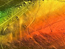
在生成的DTM上很容易识别水文特征(图5)。无人机的摄影测量法可能会产生高质量的DSM,但在植被盖下没有提供优质的DTM。为了分析水文学,一家专门从事环境的咨询公司进行了进一步的处理。DTM用于提取轮廓线,并使用QGIS的流域算法来绘制河流和流。点云的垂直横截面有助于确定植被下方的关键水文元素。DTM用于构建液压模型并模拟流量。最终,提出了三种情况以恢复植物沼泽。

Broader perspective
Wetlands occur in almost every country and every climate, and environmental studies and restoration actions are being undertaken worldwide. UAS Lidar appears to be an effective tool to characterize hydrology and could be used in various types of wetlands across the globe. The point density may be limited in some wetlands with wet or flooded areas because the infrared wavelength hardly penetrates into water. To maximize point density, it can be useful to adapt the flight planning by increasing overlap and/or reducing flight height or speed. Topo-bathymetric Lidar data may also help to overcome this issue, although airborne bathymetric scanners are expensive and heavy items of equipment to survey small areas and the UAV bathymetric scanner offering is limited. The light penetration into dense vegetation such as brambles might be improved using a high-density Lidar system with a laser frequency of 600kHz.
This survey was completed with a multirotor UAV which is well-suited for small areas. However, more extensive areas could be more cost-efficiently surveyed using a vertical take-off and landing (VTOL) UAV. Not only is such a solution suitable for larger areas in terms of flight duration/coverage (90 minutes/700 hectares), but the vertical take-off is a real asset when flying from difficult-to-access areas.

Make your inbox more interesting.添加一些地理。
Keep abreast of news, developments and technological advancement in the geomatics industry.
免费注册


