Measuring Open Pit Mines
Testing Static and Mobile Laser Scanners
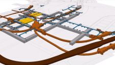
Terrestrial laser scanning enables the acquisition of massive amounts of geo-referenced spatial data in a fraction of the time required by traditional methods. The remote scanning positions also improve worker safety. The author tested static and mobile laser scanning to gauge efficacy in mining applications, including volume estimates. The high-density Lidar point-cloud data acquired during the field test allows for 3D representations of mines, generation of maps of unstable slopes, and calculating accurate volume estimates of removed material.
Figure 1, Landslide (highlighted) in gold mine in Brazil. |
Static scanning was carried out with ILRIS-3D (Intelligent Laser Ranging & Imaging System), and the mobile mapping survey was done with the Lynx Mobile Mapper. With its 10kHz data acquisition rate, a range of over 1.5km, robust field performance and portability, ILRIS-3D has great capabilities for measuring and imaging mines. We demonstrated the suitability of the system for open pit mine applications by surveying a gold mine in Brazil and a coal mine in Indonesia.
Continual Motion
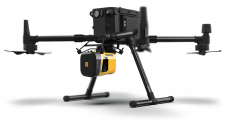
在许多适合移动映射已被证明有效ations, including highway and road construction, infrastructure database development, asset inventory, architectural design studies and environmental change detection. Mobile mapping has recently also shown its potential in mining applications. The Lynx Mobile Mapper is equipped with two Lidar sensors, each collecting data at rates up to 200kHz, that is, 400,000 points per second when using both sensors. The range influences data density: the closer to the area, the denser the dataset. Designed to be mounted on a vehicle in continual motion while carrying out the survey, the mobile mapper uses an onboard GPS receiver and inertial navigation system (INS) to geo-reference the data. We demonstrated the suitability of the system by recording a coal mine.
Gold Mine
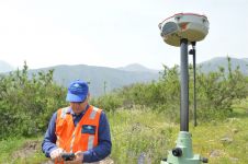
Figure 2, ILRIS-3D mounted on tripod with GPS receiver on top. |
The survey of a gold mine in Brazil was aimed at analysing a landslide which had occurred a few months earlier, and calculating the volume of loss of material (Figure 1). To capture the entire extension, 1.5km by 1km, with a depth of about 700m, the mine was scanned from six positions, the coordinates of which were determined using a GPS receiver mounted on top of the scanner (Figure 2). The 1.5-km range of ILRIS-3D enabled the acquisition of detailed scans of each mine face from its opposite side. The scan duration was ten minutes per location, and produced five million points per scan, covering the rock face with surface details at cm-level.
Figure 3, Reference plane used as a baseline for volume estimates. |
The field survey was completed in one day, whereas traditional methods would have required two weeks. The six scans were aligned to a single point-cloud and converted to a single mesh. A digital terrain model (DTM) was then generated, allowing Lidar ground data to be classified by removing all points above or below a designated surface. The entire mesh was then automatically geo-referenced based on the six GPS positions. A virtual reference plane, necessary for the calculation of volume, was established by importing a geo-referenced polyline obtained from a previous survey carried out using traditional methods (Figure 3). The volume comparison identified landslide loss of material of about 8,350m3 from the upper part of the rock face (Figure 4). In addition, contour lines were extracted for comparison with the previous survey.
Coal Mine
Figure 4, After-landslide comparison, light blue to deep purple: material loss; yellow to red: material dump. |
Canyon
Figure 5, Point- cloud collected in mine canyon by mobile laser scanning. |
Concluding Remarks
The surveys described here demonstrate that terrestrial laser scanning, compared to conventional methods, can be up to fifteen times faster. The managers of the three mines, distributed all around the world, all benefited from importing a final mesh into their own software for calculating volumes and other uses. All surveys resulted in the generation of a detailed DTM of the entire area, irrespective of terrain and access limitations. The dense point-clouds allowed geological analysis such as rock face stability assessments. The resulting accurate and extensive digital database gives mine engineers access to a wealth of information for supporting future operational decisions.
Make your inbox more interesting.Add some geo.
Keep abreast of news, developments and technological advancement in the geomatics industry.
Sign up for free


