为乌干达建立准确的大地参考网络
Facilitating Cadastral Surveys, City Developments and Road Construction
In line with the United Nations resolution to adopt a global geodetic reference network, the Government of Uganda received financing from the World Bank towards the cost of a competitiveness and enterprise development project. As part of this, Fugro was commissioned to design and implement a modern, reliable and accurate national geodetic reference network for the whole country, in addition to the deployment of a national continuously operating reference station (CORS) network.
Effective management of land resources is of vital importance to the Government of Uganda in order to support the country’s development and reduce poverty. The improvement of the land administration system, directly linked to developing the agriculture, mining and construction sectors in Uganda, is one of the country’s priorities. However, like many African countries, Uganda faces challenges in establishing the institutional and legal framework necessary for ‘good land administration’ and, consequently, lacks accurate and reliable land information, including up-to-date cadastral and topographic maps and orthorectified imagery.
转型
土地部门的转型和土地信息系统的发展表明,对现代地球网络的关键需求,以提高土地注册信息和服务的准确性。早在1960年代,使用三角测量方法在乌干达完成了水平的测量控制网络。它被引用了1960 ARC基准和Clarke 1880椭圆形,包括1,730个测量控制点和一个由3,033个基准测试的水平网络(1972年),均参考了新的Khartoum垂直数据。
Over the following decades, most of the trigonometry points and levelling benchmarks were destroyed. Several independent updating campaigns created a complex database expressed in different datums and different epochs, resulting in a land administration system that was highly inaccurate and in desperate need of updating. A new system and network called the Uganda Geodetic Reference Network (UGRN), commissioned by the Government of Uganda, promised to be a game-changer for land surveyors from Uganda’s public and private sectors because it would provide a rich new seam of reliable, accurate and easily accessible data to inform their land administration and land use planning work. The data would also be used for spatial data activities in construction and other economic sectors and for environmental protection work.

阶段1:网络设计和侦察
Fugro的18个月项目旨在更新和实施UGRN,于2017年6月开始进行三个月的现场工作。在此初始阶段,通常具有挑战性的条件,以不良维护的道路,艰难的地形和进入偏远地区和岛屿的通道不良。这项工作涉及侦察现场工作,检查现有的三角学点和平整基准,以及全国范围内寻找适合新的大地测量点的地点。在426个新的和106个现有网络站点中,只有50%被认为可用于基准转换参数计算。
To obtain community buy-in, control costs and ensure the longevity of the new system and network, the fieldwork was carried out by three Ugandan teams who were recruited, trained and supervised by an on-site Fugro expert. Occasionally, the team encountered resistance among local community members who could not see the long-term national economic benefits of the proposed work. To address this, Fugro employed four highly competent Ugandan sociologists who understood the social context and were on hand to intervene whenever required during the first three phases of the project.
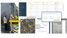
对于现场操作,Fugro开发了专用的智能手机应用程序,以监视团队的进步。该应用程序优化,以应对挑战性的环境和不良的通信网络 - 支持健康和安全,并促进了接近实时的质量保证和控制。事实证明,它比传统的纸质方法更有效,更具成本效益和一致,当地技术人员成为新技术的热情采用者。

Phase 2: Monumentation of geodetic benchmarks
第二阶段建立时通常是低估了ing geodetic networks, but it is generally the riskiest – not only for financial reasons due to the workforce and logistics involved, but also in terms of guaranteeing the quality and sustainability of the network. To reduce operational risk, Fugro selected several local organizations to carry out the monumentation of 426 geodetic markers during a six-month period. The work involved 45 people who, before starting monumentation, were provided with a detailed scope of work, methodology and rigorous training by an on-site Fugro expert. After a few weeks, the monumentation teams were managed remotely by the Fugro project team, based in France, using the online smartphone application.
阶段3:GNSS观察
The GNSS observations took 50 field days and involved up to 42 workers with 426 new points (129 first-order markers and 297 second-order markers), 60 existing points and 993 baselines. Thanks to efficient preparation, real-time QA/QC and the dedication of all team members, resurveying took only two days, equivalent to just 4% of the total observation time. This result is particularly impressive given that there were 13 teams working in different locations throughout Uganda, and the observation constraint for all GNSS receivers to record data simultaneously.

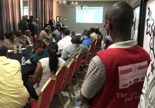
A key part of this success was the selection and training of the Ugandan staff. The surveyors received two days of intensive training, which included health, safety, security & environment (HSSE) instructions, observation strategies, GNSS equipment methodology and the use of Fugro’s smartphone application to communicate, navigate and complete the field numerical observation form. The field teams involved surveyors from the National Survey Department and three private land survey companies. This allowed knowledge sharing between Fugro and Ugandan surveyors’ communities throughout the project.
阶段4:计算和调整
对于该项目的最后阶段,该项目花了三个月的时间完成,Fugro通过双处理策略从新构建的12个连续运行的参考站(CORS)的网络中整合了其他GNSS观察结果;对于CORS网络,与Bernese和Gamit-Globk软件并行进行计算,并表现出很高的一致性。一阶和二阶网络主要是使用“嵌入订单”方法计算的,其中使用限制在其低阶网络的最小平方调整计算每个高阶网络。这是通过“完整的伯尔尼”方法来控制和验证的,涉及从零到二阶的所有观察值的同时处理和调整,并将全局结果限制为CORS网络坐标。一阶的置信度在95%的置信度下的准确性在水平估计为1厘米,垂直速度为2厘米,水平的1厘米,垂直方向为1厘米,垂直方向为二阶。

The scope of work involved computing the transformation parameters between the UGRN and the historical triangulation network. To achieve this, Fugro used trigonometry points that were recovered and observed during the project to derive all possible types of geodetic transformations between reference and historical geodetic datums.
To make best use of the GNSS CORS network for non-cadastral applications, such as development of the country’s civil engineering infrastructure, it was necessary to define an interim geoid model consistent with the vertical datums currently in use in Uganda. Contrary to the traditional approach, which consists of simply adjusting existing levelling benchmarks to EGM08 (the widely used global geoid model), Fugro used and slightly improved (using the residual Terrain Model) the EIGEN-6C4 global gravity model, best-fitted to levelling benchmarks that were recovered and observed during the project. As well as the standard longitude and latitude information, Fugro’s interim geoid model provides reliable height information from anywhere in Uganda. It is faster, cheaper and more accurate than traditional methods. However, the lack of gravity data across the country and existing levelling benchmarks mean that further field campaigns are necessary if Uganda is to have a state-of-the-art geoid model in the future.
Traditional geodesy and a new way of working
Establishing the UGRN was a huge and complicated undertaking that spanned the length and breadth of Uganda. Fugro delivered training at different stages of the project to help local technicians and surveyors derive maximum benefit from their involvement and increase their knowledge about the different products. This project was a perfect blend of traditional geodesy in challenging remote places and a new way of working. Advanced technologies for were used for field operations (smartphone application and direct payment of local surveyors) and processing (scientific software and cloud-based communication and computing) combined with stringent HSSE procedures to prevent any incidents.
UGRN是通过专用网站访问的长期,同质,准确且易于使用的解决方案,该网站允许本地调查从业人员无需本地调整即可进行互补的调查工作。这种方法旨在维持乌干达项目的高度一致性和高度一致性,例如会计调查,城市发展和道路建设。

Make your inbox more interesting.Add some geo.
Keep abreast of news, developments and technological advancement in the geomatics industry.
Sign up for free


