Combining BIM and GIS in Building Operation and Information Management
The combination of BIM and GIS technology (BIM+GIS) can provide complete and real-time data about facilities and equipment as the basis for more effective monitoring and management of information about a building.
GIS technology is already widely used in building information modelling (BIM) and urban information management such as grid systems, public information systems, etc. GIS technology can be used to visualize public information and management information, and when the GIS technology is combined with business data such as process and real-time monitoring information, the information can be managed efficiently.
The advantage of the use of GIS in building management is that it can directly reflect the geographical distribution of the building. It also reflects the various management elements of the building through vector information, and facilitates information management relating to the building through the integration and interaction of vector geographic information and business information.
Although BIM is also widely used in the architectural design and construction stage, it is still in its infancy for building management. Some high-end construction projects (such as the Shanghai Center) have succeeded in integrating operational data through BIM and have established operation management applications for asset management, energy management, environmental management, safety management, emergency management, equipment monitoring management and equipment maintenance management based on BIM to provide managers with a more direct and efficient management method.

Facility and Equipment Information Management
Thecombination of BIM and GIStechnology (BIM+GIS) can provide complete facilities and equipment information management elements for buildings. Those elements act as a foundation on which to superimpose various kinds of equipment-related data, such as intelligent monitoring information and inspection information for equipment. Different types of data can be compared, analysed and integrated as the basis for convenient and accurate information management for facilities and equipment. In the case of device failure, for instance, the GIS technology enables the device to be quickly located. Through the BIM model, all related operational management information about the device can be retrieved, such as querying the trends in the device’s recent monitoring parameters, analysing the cause of the problem and consulting the device’s repair records to see if it is a recurring problem or a problem caused by prior processing.

Spatial Management
Spatial management can be understood as various management tasks related to building space, including spatial information management, lease management and event management. Both GIS and BIM are information technologies directly related to space and they can provide a foundation for spatial management. By combining basic spatial information, rental information and event information, a more convenient spatial management visualization tool can be formed. In addition, GIS technology offers advantages in the analysis of commercial site selection. By analysing the overlaps between commercial data and spatial location (e.g. population, passenger flow, transportation, market competition, etc.), it forms a visual reference for site selection which can support decision-making for building operations such as distribution planning and investment management.
Emergency Response
Additionally, BIM+GIS plays an important role in emergency response, which is the top priority in building management. If a major incident occurs, the efficiency of the emergency response will greatly affect the success of the rescue efforts, and a successful response relies on emergency information acquisition and emergency evacuation. In terms of emergency information acquisition, BIM can visually display the specific location of the incident, as well as obtaining the latest data from surveillance cameras, smoke detectors, temperature sensors and other equipment such as video and monitoring parameters through the spatial distance analysis of GIS technology. This enables the situation to be assessed before the arrival of the first responders. Meanwhile, the BIM model can display the distribution of relevant emergency equipment (fire hoses, etc.) to assist the emergency response team. Meanwhile, GIS provides support in terms of optimal evacuation route analysis technology during an emergency evacuation.
Building Operation Service
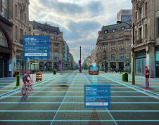
除了惯常的BIM + GIS技术还提供了各种各样的ient services to building users. For instance, in relatively complex buildings such as skyscrapers, parks and business zones, it can display information about companies or retailers in each space based on spatial data, including optimal path analysis through GIS to provide navigation services to users. When a tenant moves in, managers can use the space and device association logic of BIM to provide them with a list of equipment included in the space, and use the BIM model to show the specific situation of the original space (including concealed projects) for reference purposes.

Moreover, BIM+GIS technology has technical advantages of 3D visualization, data logic, spatial analysis and more in building operation energy management, safety management and environmental management to improve operational management efficiency and quality. The building operation management based on BIM+GIS is an upgraded version of information management. Its full application will create a new mode of building operation management. The integration and intelligent application of information will reduce the labour costs associated with operation management and will improve building management efficiency.
Make your inbox more interesting.Add some geo.
Keep abreast of news, developments and technological advancement in the geomatics industry.
Sign up for free


