鹿特队的空中双频雷达
Fit-for-purpose Approaches Are Possible Based on InSAR Technologies
土地所有权和土地使用权的问题在全球议程2030年度高度较高。50%的可持续发展目标是与土地有关的。达到与传统的地籍数据采集方法达到这些目标的非常粗略的估计数额超过500年的地籍调查工作。这清楚地说明了突破技术将有必要满足目标。请继续阅读,了解有关基于Insar Technologies的可能方法的更多信息。
(由DieterLübeck,布拉德,巴西)
在短时间内测量大面积的知名方法是空中或空间传播的遥控。在土地管理的适当型方法中,印刷图像用于参与方式的边界识别。但是雷达图像数据可以以有效的方式支持地籍边界的映射吗?在该区域中具有有希望的新方法使用空气传播的双频带(X波段和P频带)干涉性合成孔径雷达(INSAR)。由于云穿透,阳光独立性和叶子渗透等已知优势,雷达图像越来越多地用于过去十年的大规模映射和监测。
技术
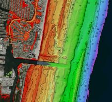
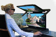
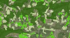
Bradar的空中双频带雷达使用X和P频段,因为它们具有最互补的映射特性。虽然仅具有3cm波长的X频带仅映射可见表面,但具有70cm波长的P频段穿透叶子并允许植被下方的地形映射。过去,该技术的主要应用是用于地形映射的干涉相处理。如今,来自幅度的高质量图像正在开辟尺度上的平面图特征提取的新视野,其具有云穿透的主要优点和宽贴图。上述机载雷达系统结合了所有这些特征,并且已经在中央和南美和欧洲映射了约230万平方公里的面积(见图1)。
检测围栏
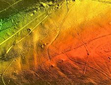
巴西的布拉达斯进行的新研究表明,P频段不仅能够检测由道路,河流或植被划分的边界,还能够检测南美洲常用的非常精细的线围栏进行划分的土地(见图2)。应用这项技术支持土地登记和地籍调查可能是加快登记流程的解决方案,并帮助保护当地人口抵御陆地抓取。
令人惊讶的结果
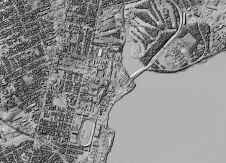
测试表明,这些围栏的特征提取可以在P波段图像中以高达20cm的高达20cm的高平面精度实现(参见图3),这符合许多发展中国家支持土地管理的要求。可以实现这种令人惊讶的结果,因为围栏的水平线起到水平极化的P波段辐射的小天线。由于围栏靠近地面,因此可以将波浪的所谓双弹跳效果回到雷达。由于这效果,来自围栏的所有水平线的信号组合成总总和,并且栅栏在图像上作为单线出现在地面上的垂直投影位置的单线。图4示出了具有遮挡区域中的栅栏网络的P波段图像的示例。除了围栏外,还可以提取其他重要特征,例如林地,道路,建筑物,单树和动物。
应用程序
The radar imagery can be applied for integral cadastral boundary detection. Most of those boundaries are visible features, defined by roads, vegetation, rivers, fences and buildings in a very efficient way. Even rivers concealed by vegetation can be extracted. Figure 5 shows an example of an area in Brazil, including orthoimages X, P, X/P colour, and extracted boundaries overlaid on the P-band image (from left to right). Additionally, digital terrain models and/or surface models can be provided by applying interferometric flights to obtain altimetric information for generation of contour lines and extraction of drainage networks, including 3D simulations. This information is useful in support of not only land administration but also rural development, infrastructure projects, forest certification, rural environmental cadastre, risk mapping, area preservation, land use mapping and topographic mapping, among many other applications.
Change detection
The radar imagery has another big advantage for change detection, namely the repeatability of illumination geometry between different flights. As opposed to optical images, this allows a systematic comparison of the images supported by image processing software. Changes in land use can be detected automatically in any type of construction. This provides the option to reconstruct ‘replaced’ cadastral boundaries.
Experiences in Brazil
The applicability of this approach has already been demonstrated in two technical feasibility studies: one close to the hydropower station of Belo Monte and the other in the district of São José dos Campos. Planimetric accuracy was measured with differential GPS at both sites. Wire fences presented an RMSE error of around 20cm and water boundaries of around 1m.
The radar survey will not completely replace ground survey, but it allows the ground boundaries to be generally defined and vectorised before going out into the field. In Brazil, for example, the interview with the landowner, the review of land boundaries and the demarcating must be carried out as a ground survey. Using radar imagery could reduce the amount of effort and time involved in conventional fieldwork by a magnitude of three to five.
Fit-for-purpose approaches
Agencies in Brazil and Latin America had not previously considered remote sensing for land administration development, and current governmental regulations do not even allow it without performing a complete ground survey. Radar surveying can speed up such a ground survey and serve as a control method. In fit-for-purpose approaches, radar imagery is now being considered as an effective way of collecting cadastral boundary data quickly and cheaply. Printed imagery can be taken into the field to compare automatically extracted features with actual cadastral boundaries. Those boundaries can be marked with a pen on top of the image. Back in office, the polygons for spatial units (parcels) can easily be identified and fed into the database with the required accuracy.
Author
DieterLübeck拥有德国FHMünchen的制图工程学位。自1998年以来,他一直在使用雷达遥感,是机载雷达映射应用的专家。他是巴西布拉德尔,巴西航空公司 - 国防和安全集团遥感师的总经理。
让你的收件箱更有趣。Add some geo.
Keep abreast of news, developments and technological advancement in the geomatics industry.
免费注册


