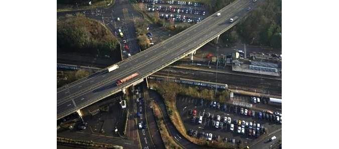
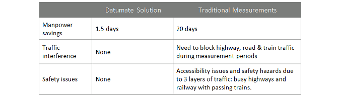
As part of the UK’s A14 improvement scheme,Datumatewas required to map a busy A14 highway junction including a highway intersection and a railway line. Traditional total station usage posed harsh accessibility issues and safety hazards due to the busy highway and the passing trains. The complex mapping included multiple infrastructure layers (bridge, road and railway line) as well as an accurate snapshot of the surrounding buildings and mapping of existing cracks to avoid future damage claims during road reconstruction work.
(This case study is brought to you by Datumate)
The A14 highway junctionThe A14 road and railway intersection.
传统的全站仪的使用提出了严厉的访问ibility issues and safety hazards due to the busy highway and the passing trains. Traditional measurements also cause huge traffic blocks during the measurements process.
A Falcon 8 drone with a 36 megapixel Sony A7R camera was used for high-resolution imaging. The aerial photography was then processed usingDatuSurveyEnterprise photogrammetry software.
Data acquisition
A Falcon 8 drone was used for quick, precise and easy image capturing. A total of 142 images were taken – from various heights.
First flight took images from the height of 80m for:
Capturing and documenting more details
Identifying smaller objects
More precise and detailed 3D model
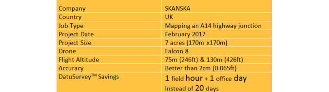
A14 road & railway intersection case studyProject facts.
Second flight took images from the height of 130m for:
Covering a larger area
Achieving a sub-2cm mapping accuracy
A total of 142 images were taken using oblique angles.
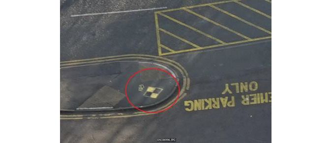
Ground control pointControl point.
Four permanent ground control points were placed in the area, enabling area georeferencing capture at any given time, without a need for professional surveyor equipment.
DatuSurvey Enterprise outputs
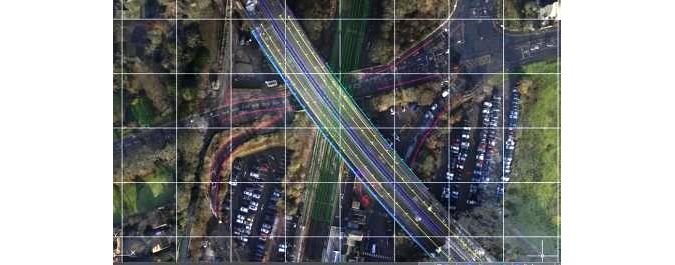
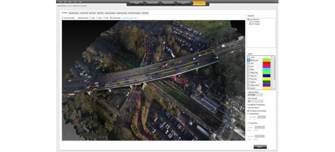
The drone’s imagery was analysed and processed using DatuSurvey Enterprise photogrammetry software to quickly generate a detailed CAD model of the area, textured 3D model and true orthophoto.
True orthophotoTrue orthophoto.
A point file, including names, codes, descriptions and coordinates of all new points, was generated. Overall, more than 450 new points were drafted directly on to the images.
The measurement accuracy of all the points wasbetter than 2 cm (0.065ft)在三维坐标。
Skanska is one of the world’s leading project development and construction groups. Skanska, a publicly traded company (Nasdaq Stockholm: SKA B), was established in 1887 with multiple companies in the Nordic region, Europe and North America.
Skanska UK, one of the UK’s top contractors with more than 5,400 employees, maintains major roads and highways in a number of regions in the UK.
DatuSurvey Enterprise benefits
For more information on the benefits offered by DatuSurvey Enterprise click on the image below. Watch also the video of the challenging A14 road and railway intersection project.
Download this article as a print friendly PDF and receive our weekly overview of the most important geomatics news and insightful articles and case studies.
Sharing this article
Ofcourse we encourage you to share this article with your peers if you enjoyed reading it. Copy the URL below or share it on your social media of choice.
This site uses cookies. By continuing to use this website, you agree to ourCookies Policy.Agree