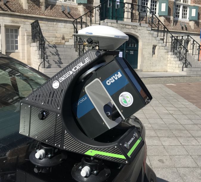
BAM Infra使用FARO陆地激光扫描仪录制了3D Road车型,并在2020年在荷兰各地的各个地方拥有创新的Beemobile移动映射系统。
BAM Infra is part of the BAM group and is active in the domestic market of the Netherlands and other European countries. As a leading and innovative company, BAM is constantly looking for improvements and innovations to optimize business processes.
An essential part of the infrastructural business process within BAM is the geodetic field in which various specialists use their specialist knowledge to serve both internal and external customers as well as possible. Traditional equipment such as tachymeters, GNSS receivers, static scanners and drones have been used on a regular basis for five years. However, this equipment lacked an important system, namely a mobile scanning system. Until recently, this service was hired externally from various market parties.

Since the introduction of Mobile Mapping (MM) systems, BAM Infra has been looking at the quality, possibilities and feasibility of an MM system within BAM Infra. Until the end of 2019, various MM products were considered and tested; however, high-end solutions from leading brands turned out to be impracticable in terms of investment level or left a lower quality impression. At the end of 2019, the company STORMBEE from Ghent (Belgium) launched an IPO of their innovative BEEMOBILE system. During 2020, this system was tested and evaluated on a number of BAM Infra projects.
2020年,BAM Infra在荷兰的各个地点记录了3D Road车型:
- 阿尔米尔市的各个地点;
- various locations / objects in the province of North Holland;
- 阿姆斯特丹,Stadhouderskade / rijksmuseum的市政当局;
- Rijkswaterstaat Volkerak桥A59-A29,与无人机测量A50,A6,N33相结合;
- 北布拉班特和盖尔德兰省的各个地点。

案例分析: Municipality of West Betuwe
由西贝图威市市政府委托,BAM Infra使用Beemobile MM系统在3D的该市进行了该城市的一部分。其中包括大约四公里的道路,包括一些交叉路口和回旋处。测量的目的是对现有地图材料进行检查,并获得现有道路表面的3D模型,以用于设计沥青覆盖模型。
收集过程
After a preliminary reconnaissance in which any obstacles and impediments were inventoried, the first step was to place the base station. The base station used by BAM was a Leica GS16, which was positioned roughly halfway along the route. Alternatively, RINEX files could also have been requested from a commercial or non-commercial provider.
将Beemobile安装在车辆上后,开始了移动调查。
Before the start of the survey, the data logging was started on the base station, which logged with an interval of one second during the entire survey. Important points when conducting the mobile survey:
- static initialization at least two minutes before the start of the survey;
- 在目标区域前至少开始200米,以初始化惯性测量单元(IMU);
- driving at a constant speed as much as possible, preferably 30km/h but up to a maximum of 80km/h;
- 避免停止:预测交叉路口 /回旋处的流量以防止这种情况。
控制点
移动数据收集后,始终收集许多控制点 /对象,以启用收集数据的检查 /校准。这些最好是高对比对象,例如彩绘表面和符号,在点云中可以清楚地识别。如果适用,也将接地控制点(GCP)应用于无人机测量。这些GCP也可以与摄影测量法结合使用,以校准记录的点云并测试质量。在后处理软件中,生成了X-Y和Z中估计精度的报告。如果准确性不足,则进行陆地测量以使轨迹文件均衡,从而满足BAM Infra的严格质量要求。∂x,y,z通过民用3D中的圆圈可视化,在那里,圆的直径达到了∂。以下是一个屏幕截图,显示GNSS信号损失使手动测量必要的位置。
处理数据
收集的数据连续处理:
- POSPAC后处理软件;
- Beflex Point Cloud处理;
- CloudCompare;
- Autodesk Recap.
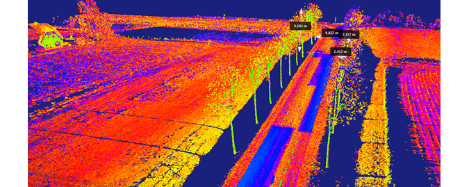
In Recap there are many possibilities to provide objects with dimensions. In the example below, this included the distance of trees from the road, the distance between trees, and the crest height. The repair areas of the road model were also clearly visible in the screenshot, as dark contrasting areas.
Further Processing
After post-processing and verification / smoothing, high-quality data was available for the design process. The point cloud was read into Autodesk Civil 3D via Autodesk Recap. The two main products designed with the collected data were:
- 新的道路模型 /重叠模型;
- design of road markings and lines.
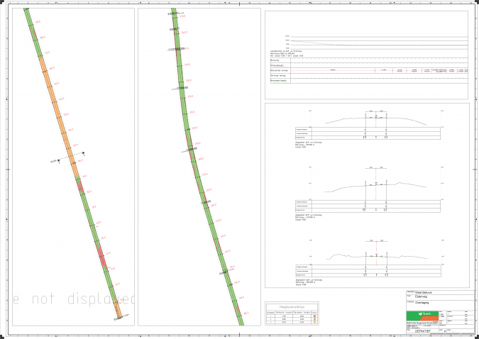
A Rehab Corridor road model was built within Autodesk Civil 3D. This made it possible to quickly generate length profiles and cross-sections and to run camber profiles.
3D道路模型
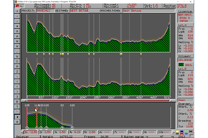
下一步是向BAM Infra使用的道路模型设计软件PaveCalc出口。
The profiles were exported from Autodesk Civil 3D to PaveCalc, see screenshot below. During this design phase, an accurate new road model could be constructed using various design parameters such as comfort slope and camber and other constructive measures that fully met the client’s requirements.
Autodesk Civil 3D
After road model modelling, the design process was completed in Autodesk Civil 3D. The final result was a design / outline drawing including asphalt or milling figures, cross-sections, length profiles and quantities. The lines generated from the scan data were also used to create road marking plans. The road marking plan forms the basis for the control line plan with which the asphalt spreading machines are controlled.
结论
通过使用Beemobile MM系统,BAM INFRA有机会快速准确地获取3D道路模型。该系统是一个不必要的测量系统,没有不必要且昂贵的额外功能。Faro的高度精确扫描仪与高质量IMU的组合使得获得高质量的3D点云,这些云在BAM Infra的工作过程中具有相当大的附加值。