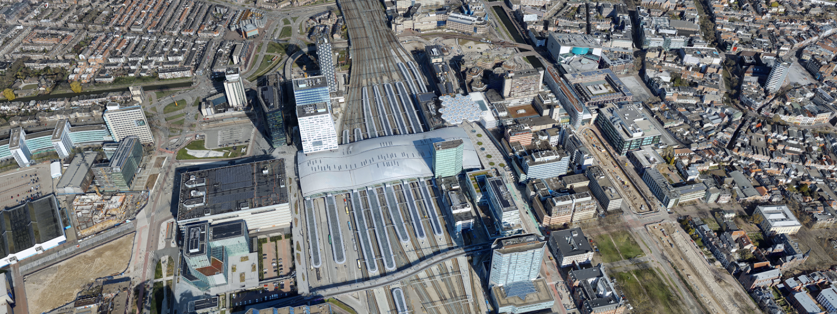
复制现实生活明明的智能数字现实提供了宝贵的见解,并支持对真实或数字世界的无限数据输入的分析和解释。它们可用于改善商业和政府客户的工作流程和计划。3DNL是整个荷兰的首个逼真的数字双胞胎。它基于机载图像和激光雷达数据,该数据使用Leica CityMapper-2航空传感器收集,并可以通过Cyclomedia的街头智能网络观看器访问HXDR,这是HXDR,这是HEXAGAN的基于云的存储,可视化和协作平台。
3D Digital Realities Are Changing the Game
几十年来,Cyclomedia提供了360度的街道级可视化,并用专利的车辆相机收集。自2018年以来,Lidar传感器已添加到专有的移动映射系统中。这些综合的基于地面的数据集可以提取光线杆,人孔和许多其他功能,从而为许多市政管理和计划应用以及其他商业活动提供见解。

Cyclomedia意识到对3D数据的需求不断增长,并希望保持其首选空中内容供应商的地位,因此认识到创新的混合数据集的好处,提供了价格和产品交付优势。通过创建3DNL,该公司生产了多功能数字双胞胎。除了在Street Smart中的直接使用外,3D数据还可以流式传输或下载以用于第三方应用程序。
“我们正在通过为客户互动并开发洞察力来创建更智能的城市,实现更有效的构造并从数据中获取信息以提供知识的新见解,从而产生重大影响,” Cyclomedia产品经理Thomas Pelzer说。。“荷兰是我们制作具有空中透视图并测试市场对这一新主张的反应的感性3D模型的主要市场。”

Leica CityMapper-2, the state-of-the-art hybrid airborne sensor, is perfectly suited for efficient and accurate urban mapping. The simultaneous acquisition of oblique imagery and Lidar point clouds produces perfectly registered consistent data. The narrow field of view minimizes occlusions while the oblique scan pattern captures building facades from all angles. One flight instead of two reduces environmental impact, decreases the cost of data acquisition, and takes advantage of limited flying windows.
However, the most important benefit of using a hybrid system lies in the quality of the data products. Image-only systems struggle to provide accurate data in shadows, urban canyons and under vegetation. The Lidar data perfectly complements image data to fill the gaps. As an active sensor, it does not require light to create accurate data points and can provide returns from underneath vegetation. At the same time, the image data is crucial for the generation of textured 3D models. A hybrid sensor provides more information, more accurate measurements and smoother surfaces in the mesh.
“正如Leica CityMapper-2中发现的那样,将LiDAR传感器添加到斜相机中,这是一个改变游戏规则的人。我们非常偏爱混合数据,并且与大型的全球公司(如六边形)加入了收购和开发方面有许多优势,” Pelzer说。“我们一直在寻找将一流产品推向市场的新方法,而Hexagon则分享了我们对创新的热情。”

Unmatched 3D Mesh Quality
为了在有利条件下全部捕获荷兰,Cyclomedia与Hexagon合作,每年2月至10月之间捕获航空数据,并产生可能的最佳数据集。使用Leica HXMAP软件处理后,将空中图像和激光雷达数据转换为网格并添加到3DNL。3D数据托管在HXDR上,并完全集成在Street Smart中。HXDR允许全球用户可视化地理空间数据和软件。
“The geometrically accurate 3D maps and models within 3DNL can be used in many applications by utilizing Street Smart’s functionality,” says Chantal Brick, marketing manager, Cyclomedia. “HxDR adds flexibility by working with us to accommodate Cyclomedia’s technical needs.”
Cyclomedia的Street Smart Viewer提供了一种访问托管数据集的简单方法,并包括可视化工具以及其他关键功能和功能,例如阴影分析,BIM模型,横截面和测量。它还支持任何领域的项目利益相关者的虚拟协作。
高质量的3DNL数据集可立即提供给用户。Cyclomedia通过订阅为客户提供了对完整综合3D数据库的访问。因此,这些数据实际上是可以访问的,而且对于有需要或渴望使用3D数据的任何人都可以在经济上访问。该产品肯定比收缩定制系列和3D网格创建便宜。

Practical Applications
Hexagon and its partners have made great strides towards creating a digital environment in which stakeholders and citizens can plan, visualize and simulate developments. Tasks such as importing CAD and BIM data, importing reality capture data, automesh of reality capture data, virtual tours and flythroughs, annotations and photosphere locations are possible.
The broad range of applications appeals to government and commercial customers. For example, a solar company may download the model of a specific house, calculate the pitch and slope, create a solar plan and present a proposal to the house owner. Construction and engineering companies can download an area of interest, design a new build and determine the most efficient access and logistics for the construction phase. A governmental agency may calculate how many trees are in a neighbourhood and plot heat pockets and perform shade analysis.
“There is great value in being able to visualize every aspect of a new structure and see how it fits with existing features before beginning construction,” explains Brick. “For example, local citizens can see how a wind turbine will look and better understand its impact on the community while working through the approval process.”

The collaboration of Cyclomedia and Hexagon on this groundbreaking 3D digital twin project demonstrates the potential for the large-scale simultaneous collection of imagery and point clouds with theLeica CityMapper-2。
Pelzer说:“我们设想3D成为解决方案的一部分,以适应用户在需要高度准确数据的各种工作过程中,就像我们通过现实捕获所提供的那样。”“我们将继续提高输入数据和输出数据的质量,并利用点云的分类来识别网格模型中的对象。通过生产多用途数据集,各种部门,例如地方政府,建筑和工程,基础设施以及风能和太阳能都可以从更好的信息中受益。我们在Cyclomedia的长期目标是扩展到具有3D的其他地理区域,而下一个里程碑将是系统地结合空中和街道层面的内容。”


